WMO says this El Niño may run off the charts used for 40 years
The UN weather agency gives a near-100 percent chance the event lasts through February 2027. Niño 3.4 weekly anomalies have already reached 2.6C. Secretary-General Guterres called the pattern supersized.

Geneva3 min read
Last updated
The World Meteorological Organization said on 3 September that the present El Niño is now firmly established, will become “very strong,” and has a near-100 percent chance of lasting through February 2027. It is the first time in the agency’s fifty-year run of El Niño updates that the forecast has been written in that language.
Celeste Saulo, the WMO secretary-general, told reporters in Geneva that if the present trajectory holds, the event “may be stronger than anything since our monitoring began, so literally off the charts we have used for the past four decades.” UN Secretary-General António Guterres called the pattern “supersized” and said the planet is in “uncharted waters, and those waters are heating up.”
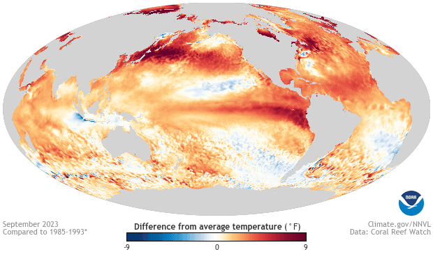
The physical marker is the Niño 3.4 index, sea-surface temperature in the central-eastern equatorial Pacific. The three-month average sat 1.5C above normal in May-July. July alone was 2.0C above normal. Weekly readings from late July to mid-August ran between 2.2C and 2.6C. The highest satellite-era monthly anomaly on record is 3.1C, set in 2015. Forecasters say this event still has months to run before its peak, which usually arrives late in the calendar year.
Below the surface the numbers are larger. In parts of the equatorial Pacific, subsurface temperatures in July and early August ran more than 8C above average. That reservoir of heat is what the WMO expects to feed further surface warming through the northern autumn.
El Niño itself is a natural oscillation. It is not caused by greenhouse gases. What has changed is the baseline. The extra heat sits on an ocean that is already warmer than it was in 1997 or 2015. Saulo said 2024, which followed the last El Niño, remains the hottest year on record “and we should not be surprised if this record is broken.” Heat stored in the ocean is released into the air with a lag, which is why the WMO is already talking about 2027 as well as the coming winter.
The agency’s Global Producing Centres see no return to ENSO-neutral or La Niña conditions inside the outlook period. Impacts will not be uniform. Strong El Niño events tend to dry parts of Australia, Indonesia and southern Africa, wet the west coast of South America, and shift the storm track over the Pacific and Indian Oceans. Saulo said the WMO has begun its largest mobilisation of national meteorological services in the organisation’s history.
Farm ministries are already moving. Indonesia has reported drought-damaged paddy. Pacific island governments are watching both rainfall and reef temperatures. Insurers who price catastrophe bonds against flood and crop indexes will now treat the WMO’s “nearly 100 percent” clause as a pricing input rather than a seasonal colour piece.
The WMO is careful on one point that headlines often skip. Event strength does not map one-to-one onto local damage. A very strong El Niño can miss a given valley. A moderate one can flood it. That is why the agency is pushing national meteorological services rather than a single global warning colour.
The forecast does not assign a death toll or a dollar figure. It assigns a probability and an intensity class. “Very strong” is the top of the WMO’s four-step scale. The next six months will show whether the sea-surface numbers overshoot 2015. The year after that will show whether the air temperature record of 2024 survives.
Continue reading
 News
NewsCrew-13 lifts off at 11:10 a.m. with a docking aimed at the fastest US arrival
Almanaque Digital DeskCape Canaveral
- News
Datafolha puts Lula four points ahead of Flavio Bolsonaro, and the runoff inside the margin
Almanaque Digital DeskSao Paulo
- News
Chinese refiners hold October fuel exports, and Singapore diesel jumps then fades